Cap Béar & Paulilles Bay: the wild coast seen from the sea
Between Port-Vendres and Paulilles stretches the most spectacular section of the Côte Vermeille. Red cliffs, historic semaphore, preserved coves and a listed bay: a landscape that can only be admired from the sea or by walking the coastal path.
Why discover Cap Béar from the sea
At 207 metres above the Mediterranean, Cap Béar is the highest point of the French rocky coast between Marseille and Cerbère. A mass of red schist that plunges straight down, crowned with a semaphore in service since 1862 and the Cap Béar fort, a listed monument watching over the entrance to Port-Vendres harbour. Above, a dense pine forest reaches down to the cliffs; below, turquoise coves that only the coastal footpath can approach on foot.
From the road, you can sense Cap Béar, you can admire it from afar along the D914 — but you never really see it. Its true seaward face, the great red cliffs plunging into the water, can only be read from the deck of a boat. That is what makes KapMer cruises so special: passing at the foot of the semaphore, hugging the rocks within tens of metres, looking up to take in the height. A unique perspective, totally inaccessible from the cliff road.
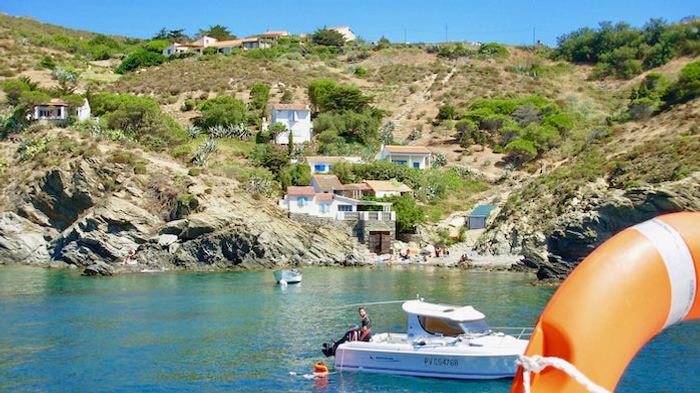
The wild coves between Port-Vendres and Paulilles
As soon as the boat clears Port-Vendres harbour and rounds Cap Béar, the coast changes face. For several nautical miles, it is red-rock coves, secret inlets, pine forests running down to the water. Here, the Côte Vermeille truly lives up to its name: the layered, oxidised schists give the rock that distinctive ochre-red tone that inspired Matisse and Derain at Collioure, just a few miles further north.
Among the coves that follow one another from the sea, you can pick out the Anse Christine, the Anse Gerbal (where coral was harvested in the 19th century), the Anse de Cosprons and several smaller, unnamed coves, summer havens for boats at anchor. All share the same features:
- Crystal-clear waters turning turquoise over sandy bottoms, and deep blue over the Posidonia seagrass meadows.
- Red schist rocks forming natural steps into the sea.
- Pine forest and Mediterranean garrigue in the background: Aleppo pines, holm oaks, cistus, mastic and rosemary.
- Accessible only from the sea or via the coastal path (GR 92) — no road comes down to them.
The skipper happily slows on the approach to these coves, so that you can take in the exact colour of the water and appreciate this preserved nature — exactly the one the sailors of the 19th century already saw.
Paulilles Bay: industrial heritage turned nature reserve
Halfway between Port-Vendres and Banyuls, the coast suddenly opens onto a vast bay forming a perfect arc: Paulilles Bay. This is our southern point, the furthest reach of our cruises, and one of the most surprising sites along the whole Côte Vermeille — for its history as much as its beauty.
From the Nobel dynamite factory to a nature reserve
From 1870 to 1984, Paulilles Bay was home to one of the largest dynamite factories in Europe, founded by Alfred Nobel's sons after their father invented dynamite. For more than a century, it produced the famous Paulilles cartridges, used notably for the Suez Canal works and in every major quarry in France. Up to 250 workers were employed on this remote site, isolated for obvious safety reasons.
The factory closed in 1984. In 1998, the Conservatoire du Littoral bought the 17-hectare site and launched an exemplary clean-up and landscape restoration. Today, Paulilles Bay is:
- Classed as a Sensitive Natural Area by the Pyrénées-Orientales department.
- Home to an interpretation centre that tells the industrial and ecological story of the place.
- Animated by a workshop restoring traditional Catalan sailing boats, saving the wooden craft of the local fishing fleet.
- Preserved as a rare Mediterranean forest, where pines, cork oaks and garrigue have fully returned.
The bay seen from the sea
From the deck of a KapMer boat, the sight is striking: the bay opens in a perfect arc, framed by the Albères range as it slopes down to the water. You can clearly make out the three successive beaches: Plage Bernardi on the north side, Plage du Fourat in the centre (the main one), and Plage de l'Usine to the south, in front of the restored buildings. A few industrial vestiges remain visible — chimneys, stone workshops, former warehouses — now blended into the reclaimed vegetation. A rare lesson in landscape: seeing how nature, in forty years, can take back a former industrial site when given the chance.
The wildlife and flora you can observe from our boats
The Cap Béar – Paulilles area is a first-rate naturalist observation zone, at the meeting point of several influences: schist cliffs, rocky seabed, protected seagrass meadows and migration corridors.
For seabirds, you will regularly come across:
- European shags drying their wings on the rocks.
- Audouin's gulls, a protected species emblematic of the western Mediterranean, which nests in the area.
- Yellow-legged gulls and terns diving straight down into shoals of fish.
Under the glass-bottomed hull of the Aquavista, you discover the Posidonia seagrass, a plant endemic to the Mediterranean which produces up to 14 litres of oxygen per square metre per day. These vast underwater meadows act as a nursery for dozens of fish species and contribute to the exceptional water quality of the Côte Vermeille.
Geologically, the area is also remarkable: you skirt layered schist cliffs in rust and purple hues, and volcanic rocks at the foot of Cap d'Oullestrell — the easternmost point of continental Mediterranean France, just after Cap Béar.
KapMer cruises to discover this coast
Two of our trips from Argelès-sur-Mer go all the way to Cap Béar and Paulilles Bay. Each with its own angle, duration and feel.
Going further: our cruises go as far as Paulilles Bay, never beyond. If you wish to explore Banyuls-sur-Mer, Cerbère or the Cerbère-Banyuls Marine Reserve (the oldest marine reserve in French Mediterranean waters), the coastal footpath (GR 92, a stunning Port-Vendres – Banyuls section) or the regional train (Perpignan – Cerbère line) remain the best options. An excellent combined day: a KapMer cruise in the morning, the coastal path or a visit to Banyuls in the afternoon.
Practical tips to make the most of your cruise
- Best time: days with a calm sea (after the Tramontane has dropped), ideally in the morning or in the late afternoon, when the low light sets the red schist of Cap Béar ablaze.
- What to bring: high-factor sunscreen, cap or hat, water, sunglasses, and a light windproof jacket even in summer (the sea breeze can cool you down). Binoculars are optional but useful for spotting the semaphore, seabirds and details of the coves.
- Durations: 1h45 for the Underwater Vision, and 1h45 for the Paulilles Bay Cruise.
- Families: both cruises are perfectly suited from a young age. Children love the Aquavista's glass-bottomed hull and the passage at the foot of the great cliffs.
Set sail for Cap Béar and Paulilles Bay
Two iconic cruises departing from Quai Marco Polo in Argelès-sur-Mer, from April to the end of September.
🎟 Book my cruiseCap Béar & Paulilles Bay — your questions
Can you sail to Banyuls by boat with KapMer?
Which cruise should I choose to see Cap Béar?
What is the story of Paulilles Bay?
Can you land at Paulilles from a KapMer boat?
How long does a cruise to Paulilles take?
- Discover Port-Vendres from the sea — historic port of embarkation, just north of Cap Béar.
- Read our guide Visiting Collioure by sea — the coast's other jewel, just a few miles further north.
- All our cruises on the Sea trips page.
Cap Béar and Paulilles are waiting for you
Choose your angle: Underwater Vision for the seabed, the Paulilles Bay Cruise for time to contemplate.