Port-Vendres from the sea: Vauban, the obelisk and the Albères
The only deep-water port in Roussillon, a historic stop for the Algiers liners, a military sentinel between two Caps: Port-Vendres reads from the water like an open book of Mediterranean history.
On the Roussillon coast there is one port unlike any other. Not a marina built in the 20th century, not a converted fishing anchorage: Port-Vendres is the only deep-water port on the south-Mediterranean coast of France between Marseille and Spain. Vauban identified it as such, Napoleon III transformed it, the Algiers liners gave it life. And it is from the sea that the historical layering of the place can be read in a single crossing.
A gulf carved out for great shipping
Geographically, Port-Vendres is a textbook case. Whereas most Mediterranean ports are built on beaches or deltas, this one cuts deep into a fault in the Albères massif. The rock plunges almost vertically into the sea: at the very entrance of the bay, depths exceed 15 metres, whereas at Collioure or Argelès they rarely top 4 metres near the quayside. This particularity — inherited from an ancient geological collapse — has allowed deep-draught vessels to find shelter here since Antiquity.
The Phoenicians had already spotted it. They named the place Portus Veneris, the "port of Venus", because they had built a temple to the goddess there. The name has lasted, slowly transformed: Port-Vendres. Seen from the open sea, you understand why: the bay opens like a sacred inlet, narrow, hemmed in, set with dark rocks — the telluric look fits perfectly with the cult of origins.
The entrance guarded by Vauban's forts
On the approach, the boat passes between two massive silhouettes facing each other. To the north, on the rocky point, the Fort du Fanal (1693); to the south, on the other spur, the Fort Mauresque. Both designed by Vauban, they were conceived as a crossfire system to block enemy vessels from entering the bay. Even today, their defensive position is striking from the deck of a boat: not a single square metre of the entrance escaped their guns.
Behind, on the southern heights, stands the Béar redoubt, and further on the Cap Béar fort, listed as a historic monument. Port-Vendres is the only French port to preserve such a coherent military system intact, readable in a single glance from the sea. It is, from the deck, a living lesson in military architecture.
The obelisk, Dagobert and the memory of Louis XVI
In the heart of the bay, planted on the jetty and visible as soon as you cross the entrance, the Port-Vendres obelisk dominates the port with its 30 metres in height. Commissioned by Marshal Charles de Mailly-Nesle, governor of Roussillon, it was erected in 1780 to the glory of Louis XVI — a one-of-a-kind monument, older than the one on Place de la Concorde in Paris.
The four bronze bas-reliefs around the base depict the king's work: abolition of serfdom, renewed navy, free trade, peace with America. During the Revolution, melting the bronzes down was seriously considered; they survived almost miraculously. From the boat, the obelisk first appears as a sharp silhouette against the sky, then sharpens as you enter. It is the first landmark once seen by the liners arriving from Algiers after two days at sea — almost the very image seen by Dagobert, a sailor aboard the "Sidi-Brahim" in the early 20th century, in the eponymous novel.
The Algiers liners and the submarine base
On the western bank, the boat passes a succession of ochre-stone warehouses and a strange building carved into the cliff: the submarine base. A reminder of another era — that of the Port-Vendres ↔ Algiers lines which, from the 1880s to the 1960s, made the port one of the most active in the Mediterranean. Liners over 150 metres long entered here, moored alongside the Customs quay, unloading wines, fresh produce, mail, travellers. The Paris-Port-Vendres rail line ended literally at the foot of the landing stage: there was a state-of-the-art rail-and-liner connection, among the most modern in Europe.
The Allied bombing of 1944 marked the end of that era. The submarine base, built by the occupier to shelter fast launches, is now disused — a striking relic glimpsed in seconds from the boat, a reminder that the Mediterranean was also a battlefield.
The memorial to the Provence Landings
On the northern heights, close to the Fort du Fanal, stands a discreet stele: the memorial to the Provence Landings, erected in memory of the troops who liberated the coast in August 1944. Port-Vendres, a major logistical arrival point, was one of the first ports brought back into service by the Allies. From the open sea, the stele is almost invisible — but the skipper points it out as you pass. It is one of those details you only learn on board.
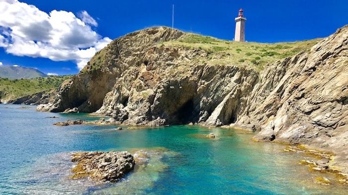
Cap Béar: semaphore, fort and wild coves
South of the bay, the coast rises in dark cliffs all the way to Cap Béar, the highest point of the French rocky coast between Marseille and Spain. Right at the top, two silhouettes: the semaphore, in service since 1862, which continuously watches over maritime traffic; and the Cap Béar fort, listed as a historic monument, tucked into the pine wood. The semaphore is still working: at the time you sail past, sailors are watching your boat from its white tower.
Below, a gallery of otherwise inaccessible coves unfolds: Anse Gerbal (where coral fishermen sheltered in the 19th century), Anse Christine, Anse de Paulilles, all the way to Cap d'Oullestrell. Red rocks that justify the name "Côte Vermeille" (Vermilion Coast), water shifting from turquoise to deep blue, pine wood that runs all the way down to the waves. This is the easternmost point of continental Mediterranean France — a natural 360° balcony.
Twilight on the Albères
If you had to choose a single hour to approach Port-Vendres from the sea, it would be twilight. The sun goes down behind the Albères range, the stone of the forts turns to red gold, the semaphore stands out as a precise silhouette against a sky shifting from orange to indigo. It is also the moment when the first lights of the bay come on — beacons, quays, restaurants — and when the port slips back into its mood as a port of call. A rare moment, and exactly what unfolds on our Sunset Cruise.
Port-Vendres from the sea — your questions
Why is Port-Vendres the only deep-water port in Roussillon?
What is the story of the Port-Vendres obelisk?
Who built the forts of Port-Vendres?
What are the Algiers liners that are mentioned in Port-Vendres?
What can you see at Cap Béar from the boat?
Why is this coast called the "Côte Vermeille"?
Approach Port-Vendres like a sailor
From Argelès, see the bay of the Phoenicians and Vauban from the very viewpoint that first set it apart.